Rainfall in Hai Duong from July 17 – 20 may reach 150 – 250 mm.

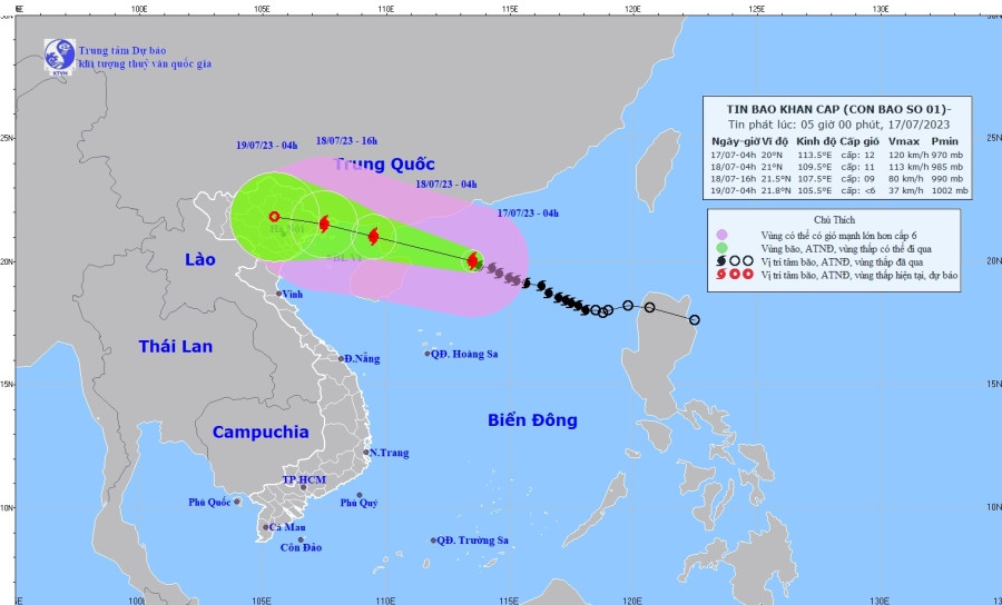
Forecast location and path of storm Talim
Talim, the first storm expected to hit Vietnam this year, was about 340 km to the east-southeast of China’s Leizhou peninsula at 4 am of July 17, with winds near the storm eye at level 11 or 12 (103 – 133 km/h) and gusts up to level 15, according to the Hai Duong Hydrometeorological Station.
The station forecast that storm Talim would move in the west-northwest direction at a speed of 15 – 20 km/h.
The storm would be about 190 km to the east-southeast of Mong Cai district, Quang Ninh province at level 11 or 12 by 4 am of July 18 and weaken to level 9 or 10 above the coastal area of Quang Ninh – Hai Phong by 4 pm of the same day.
It would further weaken and turn into a depression above the Northeast mainland by 4 am of July 19.
Storm Talim will result in moderate rain, downpours, and thunderstorms in Hai Duong province from the night of July 17 to July 20.
There is a possibility of whirlwinds, lightning, and gusts of winds during rainstorms.
Winds will become stronger, from level 4 to 6, and even above 7.
Chi Linh city, Kinh Mon provincial town, and the districts of Kim Thanh, Nam Sach, and Thanh Ha in Hai Duong will experience heavy rain, with rainfall at 150 – 250 mm or more.
Hai Duong city and the remaining districts in the province will see a rainfall of 100 – 200 mm or more.
Storm-caused disaster risks are at level 3.
VN